The United Nations General Assembly has backed an African Union-led initiative seeking to make global maps more accurately reflect the actual size of regions, particularly Africa.
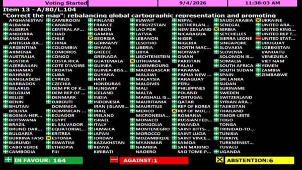
The resolution, titled "Correct the Map" and championed by Togo on behalf of the African Group, was adopted on Friday with 164 countries voting in favour. Only United States voted against it, while six, including Ukraine, Serbia, Lithuania, Estonia, Georgia, and Moldova abstained.
The African Union's Permanent Observer Mission to the UN welcomed the decision and congratulated Togo and the African Group for advancing the initiative.
The AU Commission also described the adoption as an important development, with its Chairperson Mahmoud Ali Youssouf praising Togo's leadership and the unity of African countries behind the resolution.
Youssouf congratulated Togo and President Faure Essozimna Gnassingbe for promoting the initiative on behalf of the African Group and helping secure broad international support.
"The adoption of this resolution marks an important step forward," Youssouf said.
Why AU Wants Maps Corrected
The initiative centres on the long-standing use of the Mercator projection, which was developed in the 16th century primarily for navigation.
According to the African Union Commission, the projection does not accurately convey the relative surface areas of different parts of the world and significantly understates Africa's actual size.
The AU said its campaign is aimed not simply at changing how maps are drawn but at encouraging representations based on "objective and scientifically established realities".
It has called on international institutions, educational systems, publishers and digital platforms to gradually adopt map projections that more accurately show the actual land areas of countries and continents.
The African Union Commission described the UN adoption as a "historic step toward accurate and equitable global cartographic representation".
It said the Mercator projection can make Africa appear comparable in size to Greenland, despite Africa being substantially larger.
Push For Equal-Area Maps
The AU has advocated greater use of equal-area projections, including the Equal Earth projection, in classrooms, media and international institutions.
Such maps are intended to better convey the relative size of different land masses and address distortions associated with commonly used world maps.
Youssouf said the issue extended beyond cartography and concerned how Africa is represented in relation to its actual geographical dimensions.
"Africa must be represented as it truly is: in its true dimensions and in its rightful place in the world," he said.
The African Union Commission said it would continue working with Togo, its member states and other partners to support implementation of the initiative.
The adoption provides broad international backing to efforts to address longstanding distortions in commonly used world maps. While the Mercator projection remains widely used because of its usefulness for navigation, its visual presentation can make areas closer to the poles appear disproportionately large compared with regions near the equator.
(With agency inputs)
-
Yankuba Minteh could join Liverpool in the next transfer window, says Brighton boss Fabian Hurzeler

-
"He owes me a few assists!" - Cody Gakpo jokes about his growing partnership with Alexander Isak after Liverpool pair shine again

-
KRMB asks Telangana to stop power generation from Srisailam
-
Bigg Boss 20: Full and final list of 18 confirmed contestants

-
Dressing Room Misconduct Rocks Pakistan Cricket, PCB Sends Players Home