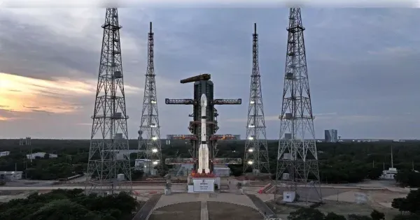
Sriharikota: After missions like Chandrayaan and Gaganyaan, another achievement has been added to the name of ISRO. The country’s first geosync observatory satellite EOS-05 of the Indian Space Research Organization has been placed in Earth’s orbit.
ISRO has successfully launched EOS-05 Geosync Observatory Satellite via GSLV-F17 rocket at 2:55 am from Satish Dhawan Space Launchpad, Sriharikota, Andhra Pradesh. This is ISRO’s first Geosync Observatory satellite, which will keep an eye on every corner of India from a height of 36 thousand kilometers in the Earth’s orbit.
What is EOS-05?
It is an imaging satellite, which is capable of clicking pictures of the Earth from space. This satellite has high resolution cameras, which can click clear pictures even from a height of about 36 thousand kilometers. The weight of this satellite is 2,367 kg. It can click photographs of the geographical area of India. Every 5 minutes, pictures will be clicked and sent to Earth through this satellite. This satellite will take about 30 minutes to take pictures of every area across India.
Weight – 2367 kg
Will take high resolution photo every 5 minutes
Monitoring of geographical area of India
Installed on 36 thousand kilometers
Happiness among scientists as well as spectators
This successful mission has been completed almost 5 years after the failure of ISRO’s GIST-1 mission. Earlier, two launches of ISRO in January 2026 and March 2026 had also failed. In such a situation, the happiness of the scientists there on the success of this mission was worth seeing. School and college students were also present late night at Satish Dhawan Space Research Center to watch this mission. There was happiness on everyone’s faces when the mission was successful.
This was the 19th flight of GSLV-F17, in which a satellite with geosynchronous or geosync payload has been launched into space. In this mission, OGV composite payload fairing with a diameter of 4 meters has been used.
Why is this satellite important?
Monitoring the sensitive borders of China-Pakistan
This mission of ISRO is considered important in many ways. With the successful installation of the satellite in space, not only India’s borders can be monitored from space, but it can also be used for disaster management, accurate weather information, agricultural monitoring and urban development. The cameras present in this satellite can click very clear and detailed pictures of the Earth.
ISRO EOS-05 mission
Farmers will benefit from monitoring agriculture
This satellite is also going to help in monitoring agriculture. Through this, the health of crops as well as sowing and yield can be accurately estimated. Not only this, expansion and construction works in urban areas can now also be monitored from space.
helpful in disaster management
The catastrophic floods in Nepal can also be monitored through EOS-05 satellite. It will also help in immediate control and disaster management of floods, storms, landslides as well as forest fires.
-
Pooran's 58* Steers MI London to Seven-Wicket Win Over Sunrisers at the Oval

-
Martin Odegaard showing signs of a major Arsenal upturn

-
Gary Neville, Jamie Carragher give their verdicts after Arsenal beat Xabi Alonso's Chelsea

-
Flipkart Deal: Vivo Y31t 5G with 7,200mAh battery available for less than ₹ 25,000

-
Before the festive season, Maruti Suzuki increased the prices of select models by Rs 20,000.