The National Weather Service has announced a severe thunderstorm watch for the Twin Cities metro area and nearby regions in Minnesota, effective until 11 p.m. on Friday. This alert also extends to parts of west-central Wisconsin, as reported by local news sources.
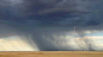
According to a post on X from the National Weather Service Twin Cities, the watch was issued at 3:25 p.m. CDT, covering central and southern Minnesota along with west-central Wisconsin. The primary concerns include large hail, strong wind gusts, and frequent lightning. Wind speeds could reach up to 65 mph, with hailstones potentially measuring up to 1.5 inches in diameter during the most intense storms.
Storm Trajectory
As of Friday afternoon, scattered thunderstorms were already advancing through west-central Minnesota and northwest Wisconsin. The Storm Prediction Center anticipates these storms will continue to move east and southeast throughout the evening, posing risks of hail and damaging winds to central and southern Minnesota and west-central Wisconsin.
Safety Precautions
A severe thunderstorm watch indicates that conditions are conducive for severe storms to form in the designated area. Residents in the Twin Cities and surrounding regions are advised to monitor weather updates closely, seek shelter indoors as storms approach, and avoid open spaces where lightning could be a danger. The watch is valid until 11 p.m. CDT on Friday.
-
German Wonderkid Lennart Karl Ruled Out of 2026 World Cup, Team Loses Their 'Next Mesut Özil'

-
Score Prediction and Lineups for Portugal vs Chile in the 2026 FIFA Matchday

-
Lionel Messi Included in Argentina’s Preliminary Squad, Coach Lionel Scaloni Considers Possible Overhaul Ahead of 2026 World Cup

-
New York Bill Proposes Gender-Neutral Terms for Parents

-
US Forces Engage Iranian Drones Near Strait of Hormuz