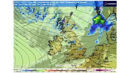

The UK is forecast for a 30-hour barrage of snowfall next week, with a number of areas set to be hit. According to the latest weather maps from WX Charts, the white stuff will arrive at 6pm on Tuesday, May 12, before persisting until 12am on Thursday, May 14.
The maps show snow hitting parts of the UK at 12pm next Wednesday, including Harrogate in Yorkshire and Darlington in County Durham. Both Newcastle and Durham can also expect flurries at the same time, with up to 12mm per hour forecast to fall. Meanwhile, areas of Scotland, including Ayr, and central and northern areas will also see snow.
According to WX Charts, the snow will arrive in north-west Scotland at 6pm next Tuesday, with up to 30mm forecast to fall per hour at this time. Meanwhile, parts of northern England, including Blackpool, Preston and Blackburn, can expect rainfall.
UK furniture retailer plunges into administration - in business for 150 years
Households paid to take bottles back to Tesco, Asda, Morrisons or Sainsbury's
The snow will then continue throughout the night and into Wednesday, with more areas forecast to receive flurries. The charts also show scattered patches of rainfall throughout England and Wales, with northern areas set to be worst affected.
In its long-range forecast, which runs from Tuesday, May 12 until Thursday, May 12, the Met Office is predicting "changeable and at times rather unsettled conditions". The forecaster adds: "This means periods of rain or showers, some of which could be heavy, for many places, though some drier interludes are also expected."
WX Charts shows the snow continuing after 6pm on Wednesday, before the final flurries fall at 12am on Thursday. Areas north of Aberdeen, including Banff and Buckie, are forecast to be the areas hit by snow at this time.
The forecaster is also predicting chilly temperatures across the UK next Wednesday, with the mercury as low as 1C in central Scotland and 3C in northern England at 6am.
It will remain cold throughout the afternoon, with temperatures forecast to remain in single digits across large parts of northern England and Scotland. At 6pm, Manchester can expect conditions of 7C, Newcastle 8C, Dundee 7C and Aberdeen 7C.
The Met Office's long-range forecast adds: "For the most part, temperatures are likely to be close to or perhaps a little below normal, with winds often blowing from a northwesterly quadrant. By the end of this period, pressure may increase towards the southwest, which could bring more in the way of dry weather here."
Cloudy across the north with some heavy shower for northern England later. Elsewhere, sunny spells with further showers developing, heaviest across Wales, the Midlands, southern and eastern England. Slightly warmer for most but cooler across the northwest.
Tonight:Evening showers fade leaving clear spells. Some rain may persist in far northern England. Local frost in the northwest, with rural grass frost and isolated fog patches south.
Saturday:Band of rain moves south across Scotland, Northern Ireland and northern England. Scattered heavy showers in Wales and the Midlands. Brighter further north. Warm in the south, colder further north.
Outlook for Sunday to Tuesday:Sunday showers clear south while the north stays cold and bright, with rain later in northern Scotland. Monday and Tuesday bring rain bands, sunny spells, breezy conditions, and below-average temperatures.