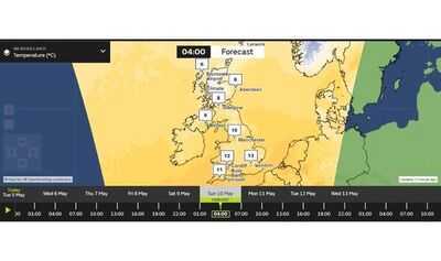

Snow is forecast to fall in the UK this weekend, with temperatures dropping as low as 6C. According to maps from the Met Office, flurries of snow will fall in Scotland during the early hours of Saturday (May 9) and Sunday (May 10) morning.
The maps show around 0.5mm of snow falling per hour in central and northern Scotland at 4am on Saturday. Heavier snow is then forecast at the same time on Sunday, with between 0.5mm and 4mm set to fall per hour in parts of Scotland. Meanwhile, the mercury will be as low as 6C in Aberdeen at 4am on Sunday morning.
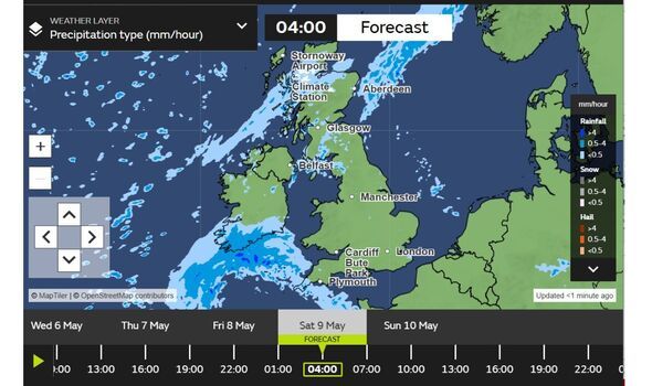
The weather maps show the snow persisting until around 10am on Saturday morning. It will be followed by a period of heavy rain hitting Northern Ireland and western and northern parts of Scotland.
Horror as Victorian-era disease rips through UK - nearly 500 new cases this year
HMRC sending 'take action' letters from May 8 - households could lose £1,406
There will then be another flurry of snowfall during the early hours of Sunday morning. The Met Office is forecasting flurries in central and northern Scotland between 1am and 4am.
Meanwhile, England and Wales are set for a mostly dry weekend. According to the maps, the South West could see some downpours of rain on Saturday morning and Sunday morning.
According to the Met Office's long-range forecast, which runs from Saturday until Monday, May 18, the UK can expect "unsettled" weather conditions. Temperatures are also set to be "near or below average" with a "risk of overnight rural frost".
The forecaster states: "Whilst largely settled conditions are likely in northern areas, there may be some rain or showers across portions of England and Wales, which could be heavy and locally thundery. However, there is a slight chance these wetter conditions could remain over the nearby Continent."
It adds: "Deeper into next week and beyond, there may be a tendency for more widely unsettled conditions across the UK, with some rain or showers at times. Whilst some occasional warm days are possible, temperatures overall are likely to be near or below average, especially in the north, with an ongoing risk of overnight rural frost."
Dry for most places today with variable amounts of cloud and sunny spells. Showery outbreaks of rain in places, mainly in the north. Turning cold in the north
Tonight:Cloud and patchy rain moving south tonight. but many places staying dry. Blustery showers in Scotland, turning wintry in the Northern Isles.
Wednesday:Most places dry with patchy cloud and sunny spells. A few showers breaking out across Northern Ireland, Wales and southwest England. Temperatures below average for the time of year.
Outlook for Thursday to Saturday:Largely dry at first with some sunny spells and fairly cool. Increasing chance of showers on Friday and rain possible in the south on Saturday. Turning warmer.
-
A Place in the Sun star opens up on new series as she shares 'trouble' while filming

-
Chantal Nobel dead: Beloved actress dies after horror car smash forced retirement

-
TV licence fee rises to £180 sparking calls for free pensioners TV licence

-
Inside the life of Euphoria's Kitty star Anna Van Patten including famous family

-
Franco Manca to close 16 restaurants for good - full list of locations