Prime Minister Narendra Modi inaugurated the highly anticipated Ganga Expressway on April 29, 2026. Stretching across 594 kilometers, this greenfield project connects Bijauli village in Meerut to Judapur Dandu village in Prayagraj, effectively bridging the gap between Western and Eastern Uttar Pradesh. The expressway is a six-lane, access-controlled corridor (expandable to eight lanes) designed to transform the state into a global logistics hub. With the inauguration complete, the expressway is now open to the public, offering a high-speed alternative to the congested NH-19 and state highways.
As per the official Ganga expressway map, the project is divided into four main construction packages. The map highlights key interchanges that connect the corridor to the Delhi-Meerut Expressway and the upcoming Noida International Airport via the Jewar Link. Future phases are expected to extend this map even further, with proposed links reaching as far as Haridwar and Ballia.
The detailed toll rates per kilometer for different vehicle categories are:
(With TOI inputs)
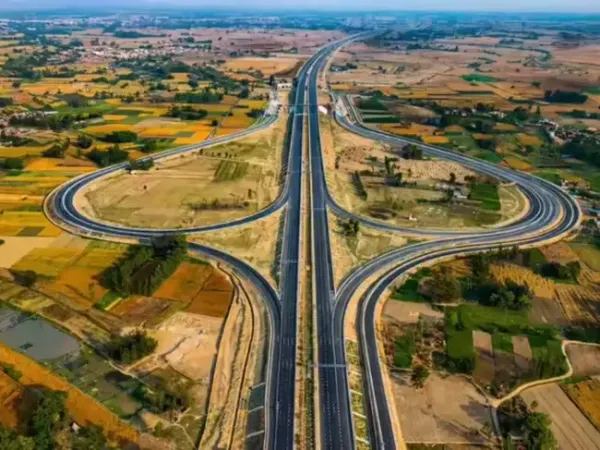
Ganga expressway route
The Ganga expressway route is strategically designed to pass through 12 key districts of Uttar Pradesh. Starting from Meerut, the high-speed corridor touches Hapur, Bulandshahr, Amroha, Sambhal, Budaun, Shahjahanpur, Hardoi, Unnao, Raebareli, and Pratapgarh, before terminating in Prayagraj. By connecting these industrial and agricultural hubs, the route is expected to boost the regional economy, providing faster access to markets for over 500 villages. Key river crossings include a 960-meter bridge over the Ganga and a 720-meter bridge over the Ramganga, both built to handle extreme weather conditions.Ganga expressway map
The Ganga expressway map illustrates a massive infrastructure web that integrates with existing corridors like the Yamuna Expressway and the Agra-Lucknow Expressway. A significant feature on the map is the 3.5-km emergency landing strip in Shahjahanpur, which has already been tested by the Indian Air Force for strategic defense readiness. Travelers can access the expressway via 18 flyovers, 7 railway overbridges, and 28 major interchanges. The map also highlights nine public utility complexes equipped with fuel stations, ambulances etc.As per the official Ganga expressway map, the project is divided into four main construction packages. The map highlights key interchanges that connect the corridor to the Delhi-Meerut Expressway and the upcoming Noida International Airport via the Jewar Link. Future phases are expected to extend this map even further, with proposed links reaching as far as Haridwar and Ballia.
Ganga Expressway toll price for 2026
With the gates now open, the Uttar Pradesh Expressways Industrial Development Authority (UPEIDA) has released the official Ganga Expressway toll price structure. For a one-way trip between Meerut and Prayagraj, car owners will have to shell out approximately ₹1,800. two primary toll plazas will be set up at the main entry points in Meerut and Prayagraj.The detailed toll rates per kilometer for different vehicle categories are:
- Cars/Jeeps/LMVs: ₹1,800 (One-way) | ₹2.55 per km
- Two-wheelers/Tractors: ₹905 (One-way) | ₹1.28 per km
- Mini Bus /Commercial Vehicles: ₹2,840 (One-way)
- Buses/Trucks: ₹5,720/₹8,760 (One-way) | ₹8.20 per km
- Heavy Haulers (7+ axles): ₹11,265 (One-way)
Ganga Expressway Speed limit and travel time details
The Ganga Expressway speed limit is set at a maximum of 120 kmph, making it one of the fastest stretches in the country. This high-speed capability, combined with the lack of traffic intersections, slashes the Meerut to Prayagraj travel time from the current 12–13 hours to just 6 to 7 hours. To ensure safety at such high speeds, the expressway is equipped with an Intelligent Traffic Management System (ITMS) and AI-based surveillance cameras that detect crashes in real-time and alert emergency response teams immediately.(With TOI inputs)